***Notes:
- Unfortunately, due to the heavy picture-content of these pages, this blog might not be suited to mobile browsing.
- Throughout this blog, GE stands for Google Earth and SMR for Site and Monument Records held by the DOENI.
- Click to enlarge all pictures in this post. Pictures are best viewed in darker conditions (details and faint features will not be visible in GE while in a sunny room for instance). Also bear in mind that the images here are copies and extractions from GE, a process which already invariably causes a loss in definition.
- Please feel free to share this blog if you know anybody who might have an interest in its contents!***
Welcome back!
First of all, I must apologise for not having updated this blog sooner, a few health issues prevented me to work heavily on the project then several other things cropped up...
I now hope to resume the publication of the County inventories as intended...
Inventory Part 2 of Co. Antrim will focus on the southwest part of the County and the distribution of sites mentioned in the text is shown below.
This post will also highlight the fact that GE can also be a great tool to gather new data for sites that are already recorded, but for which data are scant or altogether missing (e.g. for unlocated and destroyed sites).

Co. Antrim: Inventory Part 1 - Location of sites presented in this post.
***************
ANT13smr - Rath - multivallate.
Lat: 54°31'48.80"N; Long: 6° 5'51.01"W (J 23212 66316); Td: Knockadona;
Status: Recorded as ANT063:033
 SMR summary: "On a small eminence in good arable land. The
fort & adjacent house have been levelled. All that remains is a
circular area 35m diam. At the W side a very slight scarp remains 0.3m
high. This, together with the map convention suggests the site is
probably a rath."
SMR summary: "On a small eminence in good arable land. The
fort & adjacent house have been levelled. All that remains is a
circular area 35m diam. At the W side a very slight scarp remains 0.3m
high. This, together with the map convention suggests the site is
probably a rath."Although levelled, this great winter view from GE offers here a much clearer impression of this monument, found only c.170m N of raised rath ANT063:034. There is no-doubt that this site was a large rath, now showing with an external of diameter of at least 65m. The new details also indicate that the site was a multivallate monument comprised of an inner bank (surrounding the circular area formerly identified in the SMR), ditch and outer bank. There are also traces of a potential feature at SE, which may correspond to an entrance into the site.
***************
ANT14smr - Rath;
Lat: 54°31'34.66"N; Long: 6° 6'16.81"W (J 22760 65866); Td: Moneybroom;
Status: may be recorded as ANT063:076?
 On a slight eminence, remains of a well-defined rath (max. diameter 50m) showing an internal area surrounded by bank and outer ditch.
While there is nothing recorded at the present location, it should be mentioned that the SMR contains the following about ANT0633:076, a site classified as 'unlocated enclosure' and located c.150m to S:
"This enclosure is mentioned in the OS memoirs as "a fort which is now destroyed". It can not now be located."
ANT14 could either correspond to this lost monument or simply represent a new and as yet unrecorded rath.
***************
ANT15smr - Sub-square Enclosure?
Lat: 54°31'41.28"N; Long: 6° 6'42.15"W (J 22299 66059); Td: Moneybroom;
Status: Recorded as part of ANT063:032.
 Situated immediately W of Rath ANT063:032, this feature has been previously described in
various terms:
Situated immediately W of Rath ANT063:032, this feature has been previously described in
various terms:In the OS Memoirs: 7yds to W of fort, two small features 7yds in diameter.
In a field record from 1978 (SMR): "One of the smaller sites to the West is quite tracable. Looks like a barrow. Small domed area, surrounded by a ditch".
Here on GE however, this feature appears quite different since it is visible as a c.20x20m sub-square enclosure (max. external size) with a well defined wide ditch.
***************
ANT16 - Prehistoric Complex?;
Lat: 54°30'16.64"N; Long: 6° 5'11.66"W (J 23997 63486); Td: Teraghfeeva / Lissue;
Status: unrecorded.
 Situated on low ground, alongside a small tributary of the Lagan River:
traces of a possible complex of at least 9 circular features (diam. c.8-11m) showing on four different time frames.
The location was visited during Summer 2014 but the ground was too wet and overgrown to enable proper viewing of the site.


***************
ANT17 - Embanked Enclosure;
Lat: 54°31'8.40"N; Long: 6° 7'25.54"W (J 21546 65021); Td: Magheragall;
Status: unrecorded.
 Traces of sub-oval embanked enclosure truncated at N by Brookmount Rd and a railway line. Externally, it appears to have been at least 60x60m, with a bank of considerable width.
Note: Enclosure also visible on GE layers 6/5/2008 (w/ bank material standing out from ploughed field) and 24/3/2012.
***************
ANT18 - Rath (raised?);
Lat: 54°30'59.13"N; Long: 6° 7'38.69"W (J 21317 64728); Td: Mullaghcarton;
Status: unrecorded.
 Immediately S of Mullaghcarton Rd and c.340m SW of previous site ANT17: large circular raised platform, c.45m in diameter.
***************
ANT19 - Possible Earthworks;
Lat: 54°30'57.83"N; Long: 6° 8'0.52"W (J 20925 64678); Td: Mullaghcarton;
Status: unrecorded.
 About 350m W of previous site ANT18:
 complex of possible earthworks comprising a sub-rectangular bank/ditch feature c.32m in length with at least two further smaller sub-rectangular features c.12x9m set immediately behind the former.
Note: also visible on several other GE layers.
***************
ANT20smr - Rath;
Lat: 54°30'41.63"N; Long: 6° 8'4.20"W (J 20872 64175); Td: Drumsill;
Status: recorded as ANT067:012.
 SMR summary: "On flat land, with the ground falling away to
N. This is the site of one of the 2 forts mentioned in the OS memoirs
in this townland. There are no visible traces of the site remaining."
SMR summary: "On flat land, with the ground falling away to
N. This is the site of one of the 2 forts mentioned in the OS memoirs
in this townland. There are no visible traces of the site remaining."
While the SMR contain no further information about the site, it appears quite well on two different GE views from 2010 as a circular area c.42m in diameter. On the winter frame (top), it is possible to see the internal area surrounded by bank and outer ditch.

 SMR summary: "On flat land, with the ground falling away to
N. This is the site of one of the 2 forts mentioned in the OS memoirs
in this townland. There are no visible traces of the site remaining."
SMR summary: "On flat land, with the ground falling away to
N. This is the site of one of the 2 forts mentioned in the OS memoirs
in this townland. There are no visible traces of the site remaining."While the SMR contain no further information about the site, it appears quite well on two different GE views from 2010 as a circular area c.42m in diameter. On the winter frame (top), it is possible to see the internal area surrounded by bank and outer ditch.

***************
ANT21 - Enclosure;
Lat: 54°31'34.28"N; Long: 6°15'20.32"W (J 12987 65602); Td: Aghalee;
Status: unrecorded.
 Faint traces of sub-circular enclosure c.21x18m.
***************
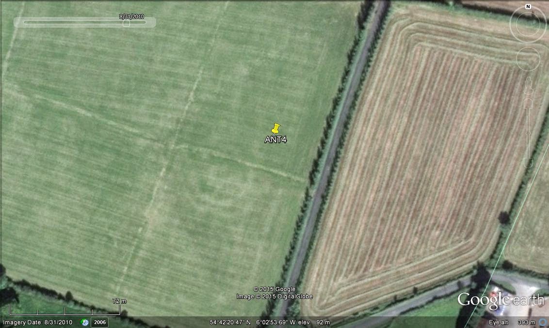
ANT22smr - Rath;
Lat: 54°31'47.08"N; Long: 6°15'5.12"W (J 13250 66004); Td: Aghalee;
Status: recorded as ANT062:042.
 SMR summary: "This site is recorded in the OS memoirs as a
destroyed fort on the land of Stewart Falloon. There are now no visible
remains of this site."
SMR summary: "This site is recorded in the OS memoirs as a
destroyed fort on the land of Stewart Falloon. There are now no visible
remains of this site."While the SMR contain no further information about this site, classified as an 'unlocated enclosure', its exact location can now be safely established and it is visible as a semi-circular cropmark of huge proportion. The site would have been about 100m in diameter.
The newly built property shown on the attached 2010 picture was absent on another GE view from 2002. It has been constructed directly on top of the NE section of the perimeter between these two dates.
***************
ANT23 - Enclosure (rath?);
Lat: 54°32'29.77"N; Long: 6°12'32.15"W (J 15967 67393); Td: Ballyscolly;
Status: unrecorded.
 Faint traces of circular enclosure, external diameter of c.44m, mainly defined by growth differential along its perimeter. Likely rath.
***************
ANT24 - Sub-rectangular enclosure;
Lat: 54°34'14.48"N; Long: 6°18'21.37"W (J 09611 70475); Td: Deer Park:
Status: unrecorded.
 On an slightly elevated position and overlooking the shores of Lough Neagh and Tunny Point:
faint traces of sub-rectangular feature, measuring c.21x16m and oriented NE-SW.
***************
ANT25 - Rath;
Lat: 54°35'47.22"N; Long: 6° 9'1.74"W (J 19589 73596); Td: Knockcairn;
Status: unrecorded.
 In an area dense with other raths, along the Glenavy river:
remains of sub-oval banked enclosure, c.53x40m. Likely rath.
Note: also visible on three other GE layers.
***************
ANT26smr - Enclosure / Mound;
Lat: 54°37'14.77"N; Long: 6° 6'28.25"W (J 22271 76376); Td: Dundrod;
Status: recorded as ANT059:032.
 This site features on early OS map editions as 'Nelsons Fort' and is summarised in the SMR: "On a brow of a hill sloping to the valley of
the Crumlin River, there are no visible remains of this site which was
described in the OSFR as a small circular mound "practically levelled".
This site features on early OS map editions as 'Nelsons Fort' and is summarised in the SMR: "On a brow of a hill sloping to the valley of
the Crumlin River, there are no visible remains of this site which was
described in the OSFR as a small circular mound "practically levelled".A couple of GE layers (see left, and 6/5/2008 layer) show this site as a circular feature with a max. diameter of at least c.32m. It appears to have been defined by a small internal mounded area, surrounded by bank and outer ditch.
Its size and features somehow contrast with the many other raths in the vicinity and classification remains uncertain.
***************
ANT27smr - Enclosure;
Lat: 54°37'36.28"N; Long: 6° 4'54.49"W (J 23935 77086); Td: Carnaghliss;
Status: recorded as ANT060:001.
 SMR: "There is no visible trace of an antiquity at this location, marked "fort" on the 1st edition OS 6"map".
While the SMR does not contain any information about this site, it is well-defined on most GE layers as a sub-oval enclosure c.49x42m.
Two further lengths of banks/ditches are also visible attached to the NW of the site and could be related to the enclosure.
***************
ANT28 - Circular feature?
Lat: 54°38'47.81"N; Long: 6° 0'5.36"W (J 29059 79442); Td: Ballyutoag;
Status: unrecorded.
 Kept this last as it is only a 'possible' site and I probably would not have mentioned it here if it was not for its proximity to Ballyutoag Court Tomb (ANT056:024).
 The site is located about c.75m NE of said Court Tomb, in the next field directly across Flush Rd. It is faintly defined as a circular feature, c.14m in diameter.
It only appears on the latest of eight GE layers (15/4/2012), onto which other possible features might be discernible in the same field (e.g. possible circular feature, c.9m in diameter, c.12m to SE of ANT28).
***************
Until later for Part 3 of the Co. Antrim Inventory...
*** If you like this post and the contents of this blog, please show your support and make a donation to the NIDAS project using the secure button at the right. Many thanks! ***