Friday 20 February 2015

The Curragh, Co. Kildare: over 30 unrecorded features and possible features

***Notes: 
- Unfortunately, due to the heavy picture-content of these pages, this blog might not be suited to mobile browsing
- Throughout this blog, GE stands for Google Earth and SMR for Site and Monument Records held by the DOENI.
Click to enlarge all pictures in this post. Pictures are best viewed in darker conditions (details and faint features will not be visible in GE while in a sunny room for instance). Also bear in mind that the images here are copies and extractions from GE, a process which already invariably causes a loss in definition.
- Please feel free to share this blog if you know anybody who might have an interest in its contents!***


Welcome back,

To illustrate the fact that smaller archaeological features can also be discovered using Google Earth, this post will focus on the Curragh, Co. Kildare, an area well known to archaeologists for its wealth of known monuments.
Apart from the recent use of the area by the horse racing industry and the military (with fascinating traces of the WWI camp and its practice trenches visible on Google Earth), the flat open plain was never extensively farmed but was in the past the focus of much prehistoric activity. Judging by the abundance of burial monuments found across the entire area (with over 100 recorded barrows in distinct clusters), the Curragh obviously held a sacred position for local past societies.
This zone is of such archaeological importance that a current project is aimed at declaring the Curragh and the neighbouring Dun Ailinne hillfort (ancient capital of Leinster) a UNESCO site.

Fig.1: Distribution of recorded sites on the Curragh, Co. Kildare (from the National Monuments Service).


Thinking that so much was already known about the Curragh, I did not expect to find a lot of evidence for new sites when I decided to glance over the area using GE years ago. Unfortunately, the GE coverage is not of the best quality for this area and only the April 2009 layer was usable for the present research. Despite the average image definition and even though the plain has been the subject of many surveys in the past, the following features still appear unrecorded (i.e. not currently in the database as of Feb 2015):

Fig.2: Location of unrecorded sites and possible sites discussed in this post.


Notes:
* Apologies to the non-specialists, this post is aimed at cataloguing rather small potentially unrecorded features and the following shots are not going to be visually impressive. For something larger and more concrete, feel free to skip the Curragh inventory and scroll down to the last site in this post: another nice find from Co. Kildare.
* I am aware that there are many features on the Curragh that relate to past military exercises or post-medieval sporadic occupation and verification on the ground would prove beneficial in some cases. In any case, I have tried to confine this list to what I would consider as genuine ancient features. 
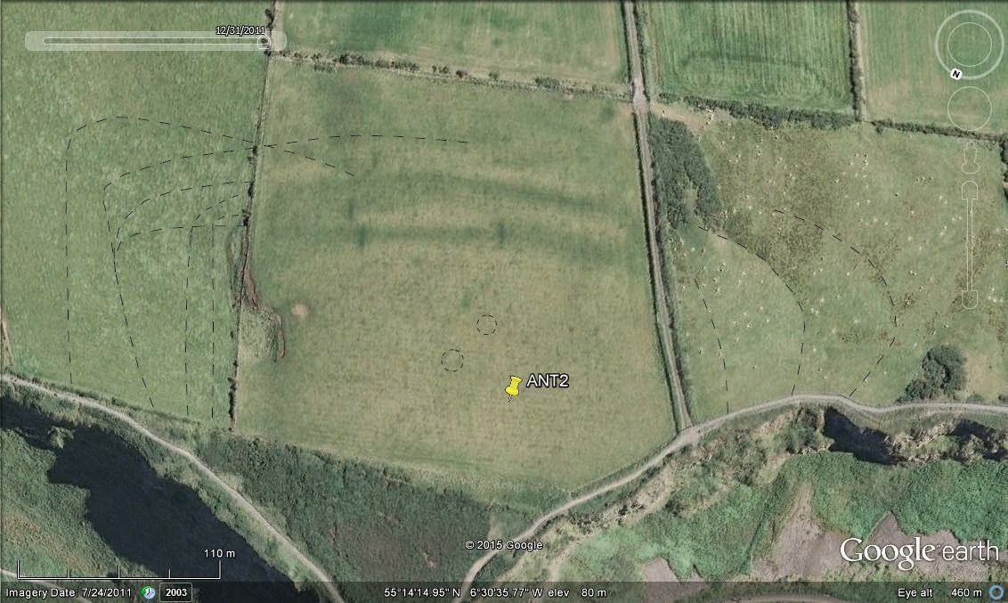
* On all pictures: visible recorded sites are shown with red markers while unrecorded features are numbered 'KDx' and shown with yellow markers.


KD1 - Sub-oval feature; Lat: 53° 7'56.72"N, Long: 6°48'13.92"W.

Only 13m to N of disturbed ring-barrow KD028-011: sub-oval enclosure c.14x11m (long axis oriented SE-NW).


**********

KD2 - Circular feature - Barrow; Lat: 53° 7'46.04"N, Long: 6°47'30.60"W.

Well-defined circular feature showing area enclosed by ditch and external bank, max. diam. c.10m.

KD3 - Circular feature - Barrow; Lat: 53° 7'51.24"N, Long: 6°47'24.16"W.

190m to NE of KD2: circular feature, max. diam. c.10m.


**********

KD4 - Sub-oval feature; Lat: 53° 8'5.65"N, Long: 6°48'38.65"W.

Sub-oval enclosure c.16x13m (long axis oriented SE-NW).


**********
Features found to the E and SE of ring-barrow KD028-074: 

KD5-KD6 - Two conjoined circular features - Barrows; Lat: 53° 8'3.15"N, Long: 6°48'45.44"W.
Two small circular features, c.4m in diameter. The southern site appears to overlap its neighbour to the north.

KD7 - Circular feature - Barrow?; Lat: 53° 8'3.46"N, Long: 6°48'46.28"W.
Just 12m to NW of above pair: faint traces of circular feature c. 9m in diameter. 

KD8 - Mutilated circular feature - Barrow?; Lat: 53° 8'1.77"N, Long: 6°48'44.64"W.
To the N of area of extensive quarrying, sharp traces of about half of a circular feature, showing arc of ditch and external bank. The arc runs for about c.25m and if circular, the feature would have been c.16m in diameter.


**********

KD9-KD12 - Four circular features - Barrows?; Lat: 53° 8'6.18"N, Long: 6°49'6.98"W (KD10)

A linear arrangement of four faint sub-circular features. KD9-KD11 are all about c.6m in diameter while KD12 appears a bit larger at c.8m in diameter.

There is a further possible site between KD11 and KD12, which would 'close the gap' in the alignment, although the imagery is not clear enough to confirm it.


**********

KD13 - Circular feature - Barrow?; Lat: 53° 8'54.02"N, Long: 6°48'26.03"W.

Within the confines of the golf course and in an unimproved area between fairways: circular feature c.6m in diameter.


**********

KD14 - Circular feature - Barrow?; Lat: 53° 9'10.12"N, Long: 6°49'5.12"W.

About 43m to SE of recorded barrow KD023-121: small circular feature c.5m in diameter.


**********

In the vicinity of barrow KD023-122:

KD15 - Circular feature - Barrow; Lat: 53° 9'18.37"N, Long: 6°49'2.75"W.
Surrounded by heavily disturbed ground, sharp traces of circular ditch enclosed by bank, max. diam. c.18m in diameter.

KD16 - Sub-circular feature - Barrow?; Lat: 53° 9'21.40"N, Long: 6°49'9.33"W.
Faint traces of sub-circular feature, c.9m in diameter.

KD17 - Circular feature - Barrow?; Lat: 53° 9'23.46"N, Long: 6°49'2.53"W.
Faint circular feature, c.9m in diameter.

**********


To ESE of recorded mound KD023-096:

KD18 - Circular feature - Barrow?; Lat: 53° 9'24.25"N, Long: 6°50'17.92"W.
c.7m in diameter.

KD19 - Circular feature - Barrow?; Lat: 53° 9'26.31"N, Long: 6°50'18.24"W
c.6m in diameter.

KD20 - Sub-circular feature - Barrow?; Lat: 53° 9'26.14"N, Long: 6°50'26.16"W
Sub-circular feature c.11x9m.


**********


KD21 - Circular feature - Barrow?; Lat: 53° 9'20.00"N, Long: 6°50'43.04"W.

Circular feature with max. diameter c.11m.


**********

In an area with several major sites but also with a lot of ground disturbance due to more recent military activity, two of the small features show a well-defined circular plan with outer bank:

KD22 - Circular feature - Barrow?; Lat: 53° 9'7.16"N, Long: 6°51'26.14"W.
Adjacent to recorded ring-barrow KD023-043: circular feature c.8m in diameter.

KD23 - Circular feature - Barrow?; Lat: 53° 9'14.36"N, Long: 6°51'31.44"W.
c.7m in diameter.


 **********

KD24 - Enclosure; Lat: 53°10'24.81"N, Long: 6°52'14.20"W.

180m to W of similar U-shaped recorded enclosure KD023-084: sub-rectangular U-shaped enclosure, possibly opened to W, c.5x4m. Could relate to military activity.


**********

KD25 - Circular feature - Barrow?; Lat: 53°10'28.39"N, Long: 6°52'44.87"W.

About 12m to E of the large ring-barrow KD022-042: circular feature c.12m in diameter.

There are potentially faint remnants of further barrows to the N, between barrows KD022-043 and KD022-81/82.


**********

Immediately N of the above sites, in an area rich with other recorded barrows:

KD26 - Circular feature - Barrow?; Lat: 53°10'32.23"N, Long: 6°52'50.36"W.
Faint traces c.9m in diameter.

KD27 - Circular feature - Barrow; Lat:  53°10'35.81"N, Long: 6°52'49.25"W.
c.9m in diameter.

KD28 & KD29 - Two circular features - Barrows; Lat: 53°10'34.56"N, Long: 6°53'0.90"W.
Pair of almost adjacent circular features, with diameters c.9m and c.10m.

**********


These two likely barrows, c.8m from each other are found c.200m E of ring-barrow KD022-047:

KD30 - Circular feature - Barrow?; Lat: 53°10'18.53"N, Long: 6°52'49.22"W.
c.10m in diameter.

KD31 - Circular feature - Barrow?; Lat: 53°10'18.34"N, Long: 6°52'48.01"W.
c.10m in diameter.


**********


KD32 - Circular feature - Barrow?; Lat: 53°10'20.03"N, Long: 6°53'8.81"W.

About 100m to N of large ring-barrow KD022-046: faint circular feature c.8m in diameter.


**********

KD33 - Circular feature - Barrow?; Lat: 53°10'30.05"N, Long: 6°53'51.84"W.

Small circular feature c.5m in diameter.

There is another faint potential feature, c.7m in diameter, a few metres to SE.


**********

The next four unrecorded sites are not located within the confined of the Curragh itself, but are found under a km to the NE of its southeastern edge (central coord.: Lat: 53° 8'17.81"N, Long: 6°46'28.51"W; see Fig.2 at top of this post).


KD34 - Circular feature - Barrow; Td: Kineagh;
c.8m in diameter.

KD35 - Circular feature - Barrow; Td: Kineagh;
Well-defined circular feature c.10m in diameter, showing potential signs of disturbance to NW.

KD36 - Circular feature - Barrow; Td: Kineagh;
Well-defined circular feature c.11m in diameter. 


About 650m to NW of the above group of three barrows: 

KD37 - Sub-circular feature - Barrow?; Lat: 53° 8'33.30"N, Long: 6°46'52.94"W; Td: Blackrath and Athgarvan.

Well-defined sub-circular feature c.11m in diameter.

(other small circular features on this image are related to farming).


**********

Lastly, as I mentioned at the beginning of this post, I thought I would also reveal another local and unrecorded site that should definitely be visually more impressive than the faint barrows of the Curragh!

The site is located 5km to NW of the Curragh and is best seen on the April 2009 GE layer:


KD38 - Large enclosure; Lat: 53°13'1.90"N, Long: 6°55'13.39"W; Td: Conlanstown; Status: unrecorded.

The site is located c.500m to ENE of another recorded enclosure in the same townland: KD017-058.

It is defined by a large internal enclosure c.59m in diameter, set slightly off-centre of a much larger external enclosure whose plan is obstructed at NW. It appears to have been slightly egg-shaped and with maximum dimensions c.140m SE-NW and c.115m NE-SW.
Furthermore, it is possible to discern a few additional traces in the interior of both the internal and external enclosures. 


**********

Right, time to bring this post to a close...

I hope that this foray into Kildare will have highlighted the benefits that can be gained from using Google Earth imagery, even in areas where much surveying has already been carried out. Knowing that some archaeological features will appear better under certain conditions and through different methods, it is worth keeping in mind that Google Earth has tremendous potential and should not be ignored (especially if the quality of the imagery were to improve with time). This point will hopefully be made clear in the next few posts since I will now attempt to publish all my new data for Northern Ireland, systematically, and by County*.


* I have received a few messages from people wondering if I would consider accepting for inclusion in this blog potential new sites in Ireland that they themselves have identified using Google Earth. I would of course be more than grateful to receive anything that would add to the present corpus of data - for both the RoI and NI. It is hoped that in the long run, this blog will act as a repository for new findings made in Ireland/NI via GE in order to better reach the archaeological communities and relevant authorities. 


*** If you like this post and the contents of this blog, please show your support and make a donation to the NIDAS project using the secure button at the right. Many thanks! ***

Tuesday 10 February 2015

A giant over the Causeway and other fortifications...


***Notes: - Unfortunately, due to the heavy picture-content of these pages, this blog might not be suited to mobile browsing
- Throughout this blog, GE stands for Google Earth and SMR for Site and Monument Records held by the DOENI.
Click to enlarge all pictures in this post. Pictures are best viewed in darker conditions (details and faint features will not be visible in GE while in a sunny room for instance). Also bear in mind that the images here are copies and extractions from GE, a process which already invariably causes a loss in definition. 
- Please feel free to share this blog if you know anybody who might have an interest in its contents!***


Welcome back! 

I know I said I was going to present a few things related to small barrows but as I was reviewing my Co. Antrim data, I had a change of mind and thought I would highlight these following sites first: 


Fig.1: Location of the sites discussed in this post


**********
ANT2
**********

ANT2 - Promontory Fort; Lat: 55°14'14.64"N, Long: 6°30'33.68"W(C 94876 44390); Td: Aird; Status: unrecorded. 

 Fig.2: ANT2 - wider location (from NNW).

The site is located along the north Antrim coastline, 3km NW of Portballintrae, and directly over the famous World Heritage Site of the Giant's Causeway. It occupies the entire headland directly above the main Causeway site and is bounded by cliffs along its northern edge. Although there are five timed layers for this location, the remains are only defined on that of July 2011: 

Fig.3: ANT2 - close up from SSW.

At first glance, the site is defined by two gently curving ditch sections stretching for over 170m across the central field. The ditches are approximately c.6m in width, with the presumed intervening banks also about c.6m in width. While these may seem like the only traces visible here, a closer look reveals the presence of many more features: 

 
- remains extend on either side of the central field in order to close-off a total area c.370x230m (extra details mainly defined in field to W by curving vegetation lines and in field to E by faint indentations/shading in the field surface). 

- presence of at least 3 ditches (and possible evidence for enlargement of the site at E although details are difficult to make up in the eastern field; see left field on Figs 3-4). 

- at least two potential internal circular features, c.12m and 8m in diameter (faint traces visible on strong zoom).

Fig.4: ANT2 - Possible interpretation of features visible on GE imagery.


Furthermore, there are a number of intriguing dark cuts set perpendicularly across the ditches of the main enclosure. These are sharply defined in the pictures shown here: two cutting the inner ditch, and another two set further down across the entranchments (top of Fig.5). I have long debated whether these could represent another feature either 'cutting' the promontory fort or being cut by it... When viewed from a certain angle (see below), it is tempting to imagine that the fortifications in effect truncate an earlier large sub-oval enclosure but I remain unconvinced (the linear 'cuts' do not really match up). Please feel free to offer any suggestion as I would dearly like to know what could cause these markings
Fig.5: ANT2 - close up of central stretch of ditches (note dark linear features cutting the earthworks).

Lastly, I have made no mention so far of the pointed headland directly overlooking the Giant's Causeway. While I long thought that the markings visible through the gorse at that location (Figs 6-7 below) must simply indicate the presence of a rocky outcrop, its conspicuous oval outline is worth highlighting here as it cannot be discounted as a natural feature yet in view of the discovered nearby archaeology (I haven't made my way to the North Antrim coast in a long time but I am eager trevisit this location on the ground and see for myself!). This feature is c.55m SE-NW and c.31m NE-SW.


Figs.6-7: ANT2- outline of oval feature at tip of promontory (natural outcrop or archaeology?).


The next two sites are also fortified constructions but of an altogether different nature, belonging firmly to more recent historical times. ANT3 and ARM1 share many characteristics on the other hand and these will be shown in turn below:
  
**********
ANT3 
**********

ANT3 - Fortifications; Lat: 54°42'9.50"N, Long: 6° 3'1.54"W (J 25727 85589); Td: Ballymartin; Status: unrecorded

This site is strategically located within a conspicuous loop formed by the Ballymartin River, about 2.5km to the E of Templepatrick. Less than a kilometer downriver to the W lie the recorded medieval settlement at Ballymartin comprising a motte, church, graveyard, well and souterrain (ANT 051:056 and ANT 051:057).  

Fig.8: ANT3 - Vertical view of the site.

The total area covered by the site is about c.120m E-W and c.100m N-S and the main observable features are as follows:

- To NE and within the loop of the river, possible remains of sub-oval mound surviving as a circular bank, c.26x23m, and surrounded by a ditch.
- To the N of the above feature and separated to it by ditch, amorphous feature c.13x10m, 
- To W, remains of a circular structure, c.19m in diameter. 
- Starting off from the previous feature and running S for c.34m before turning at right angle to E, remains or foundations of wall c.8m in width. It is regrettable that this hypothetical southern wall is not fully preserved and any traces of it are obstructed at the SE corner (N of farm building on Figs 8-9).
- On the perimeter of the site to NW, N and NE, faint traces of linear and curvilinear ditch, c.4-5m wide. 
- Inside the enclosure (relationship to the rest of the complex is not known), faint traces of potential sub-oval feature c.22x20m, itself with sub-circular internal c.7m in diameter.

Fig.9: ANT3 - interpretation of visible features. 

It should be noted that many other linear cropmarks and other raised features are visible upriver from ANT3. After verification on the historical OS maps for the area, these were found to be the remains of several corn and paper mills that were in operation along the Ballymartin River during the early 19th century. The visible remains of these mills, along with their associated mill races do not seem to match what is observable at ANT3 on the other hand. As a result, instead of being a long-forgotten industrial site, my inkling is that here we have a set of previously unknown Medieval or post-Medieval fortifications (keeping in mind that there are hints that it could be a multi-period site)


This hypothesis was strengthened when I discovered a somewhat similar complex 55km away to the SW: 

**********
ARM1
**********

ARM1 - Fortifications; Lat: 54°24'15.00"N, Long: 6°42'23.25"W (H 84050 51389); Td: Annaclarey; Status: unrecorded. 

This site is located immediately south of the Armagh border with Tyrone, along the valley of the Blackwater River and c.900m S of Blackwatertown. It is more precisely found on a strip of low land between the aforementioned Blackwater River and one of its tributaries, the Ballymartrim River, which delineates the site to W and S.  


 Fig.10: ARM1 - wider location showing local post Medieval sites.

There are many antiquities from the post-Medieval period in the immediate vicinity since the valley of the Blackwater River was the focus of much warfare between Hugh O'Neill and the English. There are three late 16th c. forts at nearby Blackwatertown, a castle and bawn at Benburb and another 16th c. artillery fort on the summit of a hill directlopposite ARM1 (Mullan Fort, TYR 062:001). 

 
Importantly, the detailed Bartlett map of 1602 for the area (left) does not indicate anything at the location of ARM1 implying that whatever the nature of these remains, they are not contemporary with that conflict. A look at the historical OS maps also fails to reveal anything pertaining to this location so it could be inferred that the site is pre-1800 but not from around 1600...


Fig.11: Bartlett map of 1602 showing location of the site (X) and Blackwatertown (B).

 Fig.12: ARM1 - vertical view of the site.

The total area covered by the site is about c.150m N-S and c.135m E-W and the main observable features are as follows:

- At the southern corner of the site, on a slight rise and directly above the Ballymartrim River, the remains of circular structure, c.28m in diameter
- Set directly to NE of above, remains of potential feature c. 12x10m. 
- At the NE corner of the site, remains of a circular structure, c.20m in diameter. A smaller internal circular feature, c.9m in diameter, is discernable in the centre of this structure (itself with smaller concentric arrangements of rings within).
- Starting off from the feature above and running for c.48m to WSW, remains or foundations of wall or bank c.4m wide.  On another shot from 17/2/2001 (Fig.14), this feature then appears to change its angle slightly, run for another c.36m before continuing into the field to the west for c.62m, now showing as a ditch on both timed GE layers. At the NW corner of the site, the ditch shows a clear angular enlargement before running SE for at least c.90m towards the bottom of the ledge where the large circular structure is situated.
- Starting off from the c.20m diameter structure again and running for c.18m SSE before turning sharply to SW for another c.45m up to the field boundary, remains of another linear feature visible as wet ground on 31/12/2010 GE layer. 
- The large depression meandering E-W through the site is probably a river palaeo-channel although its natural feature could have been used to divide the site between the lower and higher grounds.  

Fig.13: ARM1 - Interpretation of visible features.
Fig.14: ARM1 - Older view from 2001 GE layer.  


As you can see, there are many features common to both ANT3 and ARM1, whether the sites are chronologically related or not. Unless I am seriously overlooking something (or if the sites are the results of accretion of individual features through time), their origins could be bracketed as such:

Pre-1800 (not indication on early editions of the OS maps).
Post-1602 (ARM1 at least, since not shown on Bartlett's map).
And/or alternatively pre-16th c. (sites long gone by the time of the late 16th c. maps?).

Since this time period is not really my area of expertiseany comments would be greatly appreciated! 


**********
ANT4
**********

Lastly, I would like to revisit the Ballymartin area in Co. Antrim since I had made another nice discovery at this location before finding the above ANT3 site

Even though the locality is today renowned archaeologically for its Norman and Medieval past (see above in this post), there has been report of the possibility of an older settlement here, along with a pre-Norman church (see SM7 files for ANT 051:057). The evidence below provides further evidence that the area covered by Ballymartin townland was indeed a local focus of activity during earlier Medieval times already

ANT4 - Multivallate Enclosure (Rath?); Lat: 54°42'20.25"N , Long: 6° 2'55.56"W (J 25825 85925); Td: Ballymartin, Status: unrecorded.

Fig.15: ANT4 - wider location.

The site is situated less than 300m N of ANT3, on gently sloping ground, falling to S towards the Ballymartin River. It is visible on several GE layers and the picture below shows the site best as a multivallate enclosure with two sets of banks and ditches (with a max. diameter of c.55m). Although the internal space would appear quite limited, the location of the site would tend to suggest that it is  a levelled multivallate rath. 

Fig.16: ANT4 - vertical close up.


Overall, the presence of all the sites mentioned above, all within 800m of each other, highlights the strategic and political importance that the location of the Ballymartin towland enjoyed through time, from the likely multivallate rath, to the Norman settlement and perhaps ANT3. 


Thank you all for reading once again!

As for the upcoming schedule, I still plan to post a few detailed reports before shifting to the daunting task of publishing more succinct but complete County archives (If I only publish four sites per post, this project will literally take me years to complete!).


*** If you like this post and the contents of this blog, please show your support and make a donation to the NIDAS project using the secure button at the right. Many thanks! ***